.jpg)


Email received from my sister on Nov 15, 2010. Her and her boyfriend donated to my fundraiser as JD's Package Store & Redemption. This is regards to a presentation I did Nov 5 to second graders at Line Elementary School near Limerick Maine. My sister's daughter (my niece) is in this class.
_________________________________________________________________
"Hi Wendy,I thought you would like hearing that you touched a little boy's heart with your presentation. Eli who is in Sammy's class really enjoyed the presentation and listened very closely to your every word. I ran into his mother a week later and she knew just about the whole story!!! Eli talked about it at home. It especially meant something to him because he lost his sister 4 years ago to cancer. His mother/family run a non profit organization out of Newfield, Maine (next town over) called Love Grace (named after his sister). Their website is www.lovegracesociety.org I thought you would appreciate hearing this and might want to check out what they do. She said they put together care packages for families that travel a long distance to be with their children who have cancer. Everything from gas cards to snacks to blankets, etc. They use reusable totes and fill them. ........ love ya, Amy"
Monday, November 15, 2010
Tuesday, June 22, 2010
Tuesday, June 8, 2010
My National Geographic Moment

 During this year's final 40 miles in Mexico, there was no place to sleep, eat or drink. So we slept in a fisherman’s shed/shack on a
  lawn chair with no cushion. For 36 hours, we only had 2 bottles of water, 1 bottle of soda, 2 handfuls of nuts and a fried fish, while hiking in 110 degrees F with an 18 pound backpack. At this fisherman’s home on the coast, he had a family–3 children, ages 3, 7 and 8 who did not speak any English and my father speaks no Spanish. We taught them how to play hopscotch, tic tac toe, hangman, hide the toy and we read
  Spanish children’s books together. I gave them all Maine post cards; when we woke up the next morning from their shed, the little girl Leslie, age 7, was waiting for me at their kitchen table in the sand with an empty chair beside her with her post cards in her hands. It was an awesome experience—my National Geographic moment.
Sunday, May 30, 2010
We Made it to Belize!
We made it--walking from Cancun to Belize along the beach! We entered Belize on May 25, Tuesday, with no problem crossing the border, or with customs or immigration. I have some fabulous stories and pictures--especially the last 40 miles thru Mexico, including the Rio Huach crossing. After walking Ambergris Caye Belize, we entered the Belizean jungle near the Guatemala Border and stayed at a jungle camp. We hiked the jungle too. For those who donated or anyone in general: if your company or department wish for me to present my slide show from Cancun to Belize, please contact me to schedule. wmorrill@emh.org/207-973-9300. I will be posting more blogs on this website over the next few weeks. I will also pursue writing a book. Now that we have crossed the border, I am still taking donations!
 Now that we have crossed the border, I am still taking donations!
Thursday, May 20, 2010


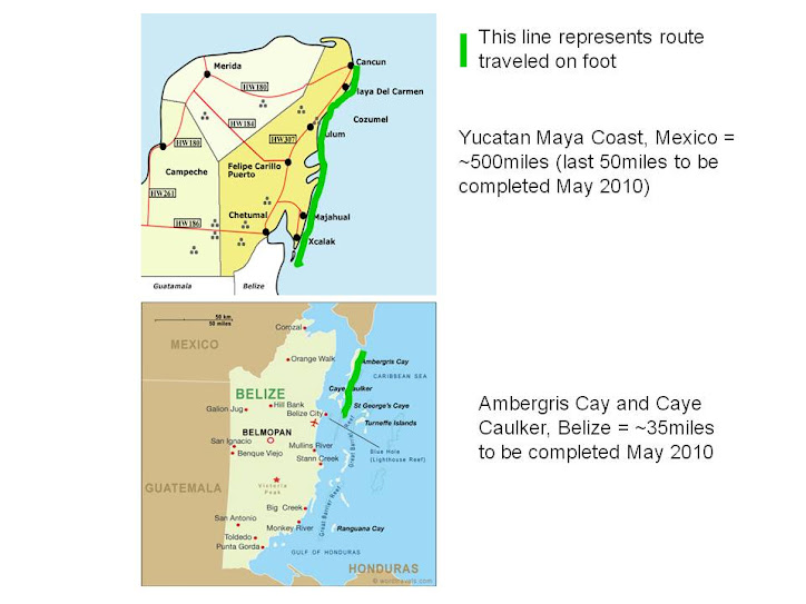
Our Plans For This Year

 These pictures are what the Yucatan coastline is like--a lot of points, almost like the coastline in Maine--(aren't there 3500 miles of it)? It is not straight like highway miles. The pictures are taken in segments, one after the other.
 _______________________________________________________________
We leave Portland Maine this Friday May21 at 6am, arrive in Cancun at 1:30pm. We will take the local ADO and Mayab buses from the airport to Felipe Carrillo Puerto, where we will stay overnight at the hotel Chan Santa Cruz. I think it is about a 2-3 hour ride from Cancun to F. Carrillo Puerto. This is my favorite Mexian pueblo. I hope the bus stops in Puerto Morelos, south of Cancun--they have awesome tamales and pina colada frozen bars at a local tienda that I would like to get for lunch!
We will meet the author Mari Pintkowski (who wrote the 2 articles about us on Sac-be.com and the owner of La Selva Mariposa, http://www.laselvamariposa.com/) for breakfast at the El Faisan Y El Venado restaurant on Saturday at 7am before we go to the coast to start hiking.
We start hiking in Punta Kanecaxh, about 10miles south of Majahual on Saturday, hopefully around 10am. There appears to be cabanas dotted along the coast for about 15 miles, then nothing for about 6 miles before we get to Rio Huach, which is one of our biggest obstacles this year (see previous post Rio Huach). We still don't know how we are going to get across. After the river, there are more cabanas, then nothing again for another 15 miles, until we reach XCalak. We will stay at Costa De Cocos where we hope to arrange a boat to take us across the MX-Belize border channel. This is our other obstacle. We need to hire a boat and hope the weather is right, check out of MX and cross the Belize border legally. The 3rd obstacle are mangroves--a lot of them; we may get around them by walking in the shallow water (there are snakes) or going thru the jungle and finding the road to bypass the mangroves. The total mileage left of Mexico is about 35-50 miles of coastline--but hard to say from looking at a map. We are hoping to hike this MX part in 2-3 days. See photos.
Once in Belize we will hike Ambergris Caye and Caye Caulker. We hope to hop from island to island using water ferries or water taxis. Ambergris Caye is about 25 miles long and in the north, from what I can tell on Google Earth, there is nothing but rock--no hotels until after about 10 miles. After hiking these 2 islands, if there is time, we want to go inland to a Belize jungle camp.
Sunday, May 16, 2010
Daily Routine
To get to our starting point on the coast for the year, we always travel like the locals do: by taking the ADO or MAYAB bus from the airport, a collectivo around town for 80 cents or less, a chicken bus or hitchhiking.  The local bus is about $4-15 (a fraction of the cost of tourist buses and taxis), and it usually has air conditioning, a movie, and I get to practice Spanish! To get the bus, one needs to stand on the side of highway 307 (the only major road in Quintana Roo), and wave the bus down. This is what a bus station looks like along the highway.
 To travel like the locals do, however, you need to know some basic Spanish, be adventurous, and not be on a timed schedule.


The local bus is about $4-15 (a fraction of the cost of tourist buses and taxis), and it usually has air conditioning, a movie, and I get to practice Spanish! To get the bus, one needs to stand on the side of highway 307 (the only major road in Quintana Roo), and wave the bus down. This is what a bus station looks like along the highway.To travel like the locals do, however, you need to know some basic Spanish, be adventurous, and not be on a timed schedule.We usually get up in the morning around 5:30-6am, start hiking around 6:30am and stop around 3-4pm, depending on where we are and how long to the next town. It is best to start walking early in the morning before the sun gets too hot. Sometimes we even skip breakfast to get an early start and find some place to eat along the way around 9-10am. (more on food in a near future post) We have also been known to hike at 7:30 in the evening because it is cooler.
It is best to start walking early in the morning before the sun gets too hot. Sometimes we even skip breakfast to get an early start and find some place to eat along the way around 9-10am. (more on food in a near future post) We have also been known to hike at 7:30 in the evening because it is cooler. We usually take a short break every 2 hours, in the shade and go swimming in the ocean to cool off. It gives us a much needed burst of energy. My father  really enjoys this.
 really enjoys this.
 To get thru difficult, hot and tiring hours of endless coastline, I sometimes talk to myself that if I can just put one foot in front of the other and keep walking we will eventually find the next town. I also like to practice my Spanish to myself while walking. I practice over and over the words of what I will say when I meet the first local person in the next town. One time I wanted to learn the sentence of how can I find some young boy to hire to carry my backpack for the next 30 miles down the coast! Just like Peissel did when he walked this coast in 1958! I also like to study the terrain as I am walking and find shells, seeds, plants, animals etc. 


What does Dad do when he is walking in the 108 degrees F for 15-20 miles a day? I think he is always ahead of me because he is watching out for things ahead of us, looking out for the military posts searching for drug packages, and pushing on to get around the next point to see if there is a town. The MX military/police makes him nervous . There are military posts all up and down this coastline, it seems like in every town. I think he is being a Dad when he does this and looking out for us. Or maybe he is looking for a clothing optional hotel??
 . There are military posts all up and down this coastline, it seems like in every town. I think he is being a Dad when he does this and looking out for us. Or maybe he is looking for a clothing optional hotel??
I like it when my Dad plays this game with us when we are hiking every year: he always asks me what would he do if he found a treasure of $100,000 cash on the beach? Since we can only claim something like $10,000 on the plane home, he always says that he would hide it each year in the exact same spot and take $10,000 home each time--after splurging some of it in a rich resort with a lot of fruit daquiris!! I always ask him how is he going to make sure he knows where he hid the treasure the next year. The subject of off shore banking and hiring a boat comes up too.
 asks me what would he do if he found a treasure of $100,000 cash on the beach? Since we can only claim something like $10,000 on the plane home, he always says that he would hide it each year in the exact same spot and take $10,000 home each time--after splurging some of it in a rich resort with a lot of fruit daquiris!! I always ask him how is he going to make sure he knows where he hid the treasure the next year. The subject of off shore banking and hiring a boat comes up too.
When we find the next town, we always get drinks first (usually a lot of ice cold purified water, Cokes and pineapple juice), then a local hotel, cabana or tent cabin. We do bring along Army hammocks and mosquito nets in case we need to sleep on the beach. There has only been one time near Punta Allen that we had to use our hammocks. 


After checking into to our rooms, we usually crash and relax, then shower and find something to eat in the pueblo. There has been only once or twice where these small local hotels along the beach in the 450 miles have had TVs in the room. One hotel even had satellite TV and we were able to watch the NBA playoffs!!
 and find something to eat in the pueblo. There has been only once or twice where these small local hotels along the beach in the 450 miles have had TVs in the room. One hotel even had satellite TV and we were able to watch the NBA playoffs!!
Saturday, May 15, 2010
Survivor and the Bag Lady

Whenever we are hiking along the Mayan coast, my Dad always says I look like I should be on the tv show Survivor!
 After about 4 days of hiking, carrying around my backpack and everything I own wherever we go, I feel like I am a bag lady. Especially when I need my scarf around my shoulders/neck because of the sun, my Tshirt under my backpack straps because they hurt my sunburn, and my camera pack around my waist, my backpack on my back, my sunglasses around my neck, and sometimes my sandals in each hand, depending on if there is sand, rocks, sand, rocks etc! (If I wear my Tevas sandals when we are hiking on rocks, then leave them on when walking in the sand and water, sometimes I can get blisters that way--when they are wet, slippery and have tiny rocks in them). It just depends on the terrain for that day.
¿Dónde está el baño?


We found this makeshift toilet in the middle of nowhere on the beach, near the edge of the water, while hiking. Perhaps a group of fishermen or kids built it? Did we use this bathroom facility?? NO! 

Tuesday, May 11, 2010
XCassel (or X'Cacel) --is it a real town?

There is a 'town' on my topographical maps that says XCassel. We wanted to get a lunch in this town. We found this pueblo while hiking from Paa Mul to Tulum and needed food and water badly, we might had even stayed in a hotel. But, from the beach, this was all that X'Cacel had: 2 buildings!
 And the one local person in this building didn't know where to get water and had no food! Not even a bathroom. This is where we ate lunch: underneath a lean-to, while eating our trail mix and warm water.
 This is all we had to eat or drink for 8 hours.
  It was a rough day. X'Cacel is known for its seaturtle nesting grounds.
Sunday, May 9, 2010
Obstacles from Puerto Morelos to Mahahual
These were the obstacles from Puerto Morelos to Mahahual Mexico:
Puerto Morelos Federal Zone/Marina--had to walk around town/inland to find the beach again.


Puerto Morelos Federal Zone/Marina--had to walk around town/inland to find
 the beach again.
Puerto Aventuras Marina: it was a maze trying to find the beach again! And it was noontime and very hot walking inland around the pavement! We came across this gate, which, we thought the blue color was the other side of a lagoon (ie: water and beach), but as we got closer it was just the gate painted blue! That was how delirious we were! My father also thought he saw something dark and big run across the trail in the jungle--like a large cat! 

The inlet: but of course we made a raft to get across. See other post: The Raft.
Yal-ku Lagoon (snorkeling park): all beaches in MX are public, but as soon as you step on the property you might get yelled at or dogs will come after you. At Yal-ku lagoon, there is no beach, we had to walk around on the flat ledges, which were actually slimy and slippery in spots, this is where I fell on the rocks, but I did not get hurt, just scraped my leg. As we were walking around the park, the staff came out and yelled at us. We had to go back to the highway to find beach access! But we snuck thru the barb wire and found a path to the beach.

Mangroves and swamps!! Definitely problems for 2 hikers!
Xel-Ha: In 1958, Peissel had to walk AROUND this large inlet, but today it is a popular snorkeling park so there is a bridge. Although the inlet was not an obstacle for us, finding the beach ag ain was because there were only rocks, cliffs and mangroves in this area. It was also almost dark at this time, and we had no water left. That is why we decided to go to Tulum for the night, then start again the next day going north near Xel-Ha.
Tulum Cliffs: we hired a Mayan fisherman to take us across the cliffs in a boat, but we did walk back across some of the cliffs to explore a ruin not visited by most tourists.

Mahahual cruise ship dock with a 10 foot wall: didn't take a picture of this 10 foot wall because we were being yelled at in Spanish by security that said we could not climb it and enter the town! We had to turn back into the jungle to find the road to take us to town--only to find the road blocked by a fence, but luckily the fence had a large hole in it!
Dogs: sometimes there were 7 dogs chasing us at one time, barking, growling and showing their teeth! One time we even had to swim in the ocean to get rid of them! There was only one dog out of the 400-500 miles that was our true friend. 

River Crossing Problem 2010
 Rio Huach: This river is located along the Yucatan coast between Mahahual and XCalak, MX. On the locogringo.com aerial photos it shows a bridge, but on google earth it shows there is no bridge. I just confirmed today that the bridge burnt down in 2006 and there is no replacement! We are hiking from the north to south. The nearest settlements/buildings/pueblos are 6 miles north of this river. I called my dad today in a panic, he said not to worry, that he can get us over it. He reminded me that last time we needed to get over an inlet during this hike, he made a raft. I was told that this Rio Huach has crocodiles in it! I hope I see one. I was also told that on the other side of this river there is hotel property where the clothing is optional....when I told my dad this, that was incentive enough for him to get us over. I will keep walking, thank you, once we cross the river. I think we can wait on the north side of this river and wave to someone with a boat to take us across. If anyone else has any great ideas, I'm open to them. It so
 unds like I will be coming home with yet another story of how we get thru these obstacles.
PS: In 1958, the author Peissel finally found a boat to take him to Belize from Mahahual, so he did not mention this river.
Friday, May 7, 2010
What I Take In My Backpack

2 shorts, 2 tank tops, 1 T-shirt, 2 underwear, 1 pr socks (and after 9 days--boy, do they smell!), 1 light skirt, 2 bathsuits and cover up/shawl that I use to cover my head and shoulders from the sun, water sandals (Tevas), sneakers, flip flops, 15 SPF sunscreen, notepad and pen with duct tape around it, machete, 3x12oz bottles of water, sunglasses, hat, trimmed maps, pesos and USD, credit card, driver license, passport, plane tickets, child size toothbrush with dental floss wrapped around, shampoo, mosquito net, hammock, 1 cargo pants (for plane and jungle), 1 bandana, digital camera, deodorant, razor, small brush, trail mix, travel Spanish book, tissues, medications such as pea size antibiotic and hydrocortizone creams in sterile microfuge tubes, 4x Immodium AD, 4x Tylenol, 2xback pills, 2x Benadryl, 4x Excederine, a fanny pack and a light canvas bag, large trash bag, and Maine post cards for locals.
By the way, this picture has a story: One early morning, I washed my clothes in a hotel and tied them off the back of my backpack. After breakfast, we caught a collectivo in town to get to the beach, and the collectivo was full of Mexican construction workers--but we were still able to get on, we just had to stand in the front with our backs to the workers. Everybody seemed to be laughing at me. It wasn't until 2 hours later as we were hiking that I realized I left my underwear hanging off my backpack! My clothes were still wet of course, because nothing ever dries in the tropics. 

Subscribe to:
Posts (Atom)


